七星主峰-東峰步道:修訂版本之間的差異
出自六年制學程
(→預定行程表) |
(→參考資料) |
||
| (未顯示同用戶所作出之44次版本) | |||
| 第 1 行: | 第 1 行: | ||
| − | === | + | ===七星主峰-東峰步道=== |
| − | + | <table> | |
| − | + | <tr> | |
| − | + | <th><img style='width:500px' src='http://www.ymsnp.gov.tw/filesys/images/ch/tours/footpath/mt_qixing/qixing/linepicture06-01.jpg' /></th> | |
| − | + | <th><img style='width:500px' src='http://www.ymsnp.gov.tw/filesys/images/ch/tours/footpath/mt_qixing/qixing/linepicture06-03.jpg' /></th> | |
| − | + | </tr> | |
| + | <tr> | ||
| + | <th>七星主峰東峰步道示意圖</th> | ||
| + | <th>七星主峰東峰步道地形圖</th> | ||
| + | </tr> | ||
| + | </table> | ||
===預定行程表=== | ===預定行程表=== | ||
| − | *捷運劍潭站1號出口→搭乘紅5→陽明山公車總站→ | + | *捷運劍潭站1號出口→搭乘紅5→陽明山公車總站→ 108遊園公車→小油坑站下車→七星主峰→七星東峰→七星公園→七星山苗圃登山口→陽明山公車總站→劍潭站或士林站放學 |
| − | + | ||
| + | *[https://www.google.com/maps/d/embed?mid=zNm_6bfQCCno.kRjqcMKmonpk 七星主峰-東峰步道GIS路線圖] | ||
| + | <table class=nicetable width=500> | ||
<tr> | <tr> | ||
<th align=center bgcolor=#ffff66><B>時間</B></th> | <th align=center bgcolor=#ffff66><B>時間</B></th> | ||
| 第 21 行: | 第 28 行: | ||
<tr> | <tr> | ||
| − | <th><font color="red"> | + | <th><font color="red">09:20</font></th> |
<th align=left><font color="red">集合完畢,搭乘紅5公車(大都會客運)</font></th> | <th align=left><font color="red">集合完畢,搭乘紅5公車(大都會客運)</font></th> | ||
</tr> | </tr> | ||
| 第 71 行: | 第 78 行: | ||
</table> | </table> | ||
| + | |||
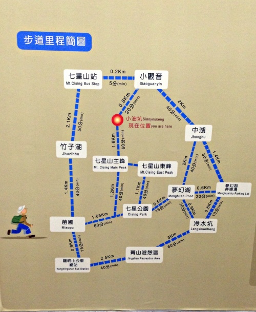
| + | ===爬山步道里程簡圖=== | ||
| + | [[檔案:步道里程簡圖.JPG|500px]] | ||
| + | |||
| + | ===集合、解散時間地點=== | ||
| + | *集合時間:2015.12.02 (三)09:00 | ||
| + | *集合地點:捷運劍潭站1號出口集合 | ||
| + | *解散時間:2015.12.02 (三)16:00 | ||
| + | *解散地點:捷運士林站或劍潭站解散 | ||
| + | |||
| + | |||
| + | |||
| + | ===行走順序=== | ||
| + | #海豹組 | ||
| + | #熱狗組 | ||
| + | #楓凜組 | ||
| + | #飛龍組 | ||
| + | #威風組 | ||
| + | |||
| + | |||
| + | |||
| + | ===攜帶物品=== | ||
| + | #水 | ||
| + | #毛巾 | ||
| + | #外套 | ||
| + | #悠遊卡 | ||
| + | #塑膠袋(裝濕衣服) | ||
| + | #午餐乾糧 | ||
| + | #備用衣物 | ||
| + | #輕便雨衣 | ||
| + | #登山杖(需要者請自行攜帶) | ||
| + | |||
| + | ===紅5路線圖=== | ||
| + | <table> | ||
| + | <tr> | ||
| + | <th><img style='width:500px' src='http://e-bus.taipei.gov.tw/newmap/Tw/RouteImageFile?rid=10821' /></th> | ||
| + | </tr> | ||
| + | <tr> | ||
| + | </tr> | ||
| + | </table> | ||
| + | |||
| + | ===108遊園車路線圖=== | ||
| + | <table> | ||
| + | <tr> | ||
| + | <th><img style='width:500px' src='http://e-bus.taipei.gov.tw/newmap/Tw/RouteImageFile?rid=10822'/></th> | ||
| + | </tr> | ||
| + | <tr> | ||
| + | </tr> | ||
| + | </table> | ||
| + | *去程搭車參考時間如下: | ||
| + | #10:00 | ||
| + | #10:30 | ||
| + | #11:00 | ||
| + | #11:30 | ||
| + | #12:00 | ||
| + | #12:30 | ||
| + | #13:00 | ||
| + | #13:30 | ||
| + | #14:00 | ||
| + | #14:30 | ||
| + | #15:00 | ||
| + | #15:30 | ||
| + | #16:00 | ||
| + | |||
| + | ===260路線圖=== | ||
| + | <table> | ||
| + | <tr> | ||
| + | <th><img style='width:500px' src='http://e-bus.taipei.gov.tw/newmap/Tw/RouteImageFile?rid=10823'/></th> | ||
| + | </tr> | ||
| + | <tr> | ||
| + | </tr> | ||
| + | </table> | ||
| + | |||
| + | ===雨備方案=== | ||
| + | *[http://blog.xuite.net/bobowin/me/22536508-%5B+%E5%8F%B0%E5%8C%97%E6%8E%A8%E8%96%A6%E6%99%AF%E9%BB%9E+%5D+%E5%8C%97%E6%8A%95%E5%9C%96%E6%9B%B8%E9%A4%A8~+%E7%B6%A0%E5%BB%BA%E7%AF%89%E4%B8%80%E6%97%A5%E9%81%8A 北投圖書館] | ||
| + | |||
| + | ===參考資料=== | ||
| + | *[http://www.ymsnp.gov.tw/index.php?option=com_linemap&view=linemap&id=6&gp=0&Itemid=132 陽明山國家公園] | ||
| + | *[http://ebus.taipei.gov.tw/ 大臺北公車] | ||
| + | *[http://blog.xuite.net/bobowin/me/22536508-%5B+%E5%8F%B0%E5%8C%97%E6%8E%A8%E8%96%A6%E6%99%AF%E9%BB%9E+%5D+%E5%8C%97%E6%8A%95%E5%9C%96%E6%9B%B8%E9%A4%A8~+%E7%B6%A0%E5%BB%BA%E7%AF%89%E4%B8%80%E6%97%A5%E9%81%8A bobowin旅行攝影生活] | ||
2015年12月1日 (二) 11:58的最新修訂版本
目錄
七星主峰-東峰步道
 |
 |
|---|---|
| 七星主峰東峰步道示意圖 | 七星主峰東峰步道地形圖 |
預定行程表
- 捷運劍潭站1號出口→搭乘紅5→陽明山公車總站→ 108遊園公車→小油坑站下車→七星主峰→七星東峰→七星公園→七星山苗圃登山口→陽明山公車總站→劍潭站或士林站放學
| 時間 | 地點 |
|---|---|
| 09:00 | 捷運劍潭站1號出口集合 |
| 09:20 | 集合完畢,搭乘紅5公車(大都會客運) |
| 10:00 | 到達陽明山公車總站 |
| 10:30 | 搭乘108遊園公車 |
| 11:00 | 小油坑站下車 |
| 12:10 | 七星主峰(H1120m) (攻頂、用餐) |
| 12:40 | 前往七星山東峰 |
| 13:20 | 前往七星公園 |
| 14:40 | 抵達七星山苗圃登山口 |
| 15:10 | 步行至陽明山公車總站 |
| 16:00 | 搭乘260或紅5可至捷運士林站或劍潭站放學 |
爬山步道里程簡圖
集合、解散時間地點
- 集合時間:2015.12.02 (三)09:00
- 集合地點:捷運劍潭站1號出口集合
- 解散時間:2015.12.02 (三)16:00
- 解散地點:捷運士林站或劍潭站解散
行走順序
- 海豹組
- 熱狗組
- 楓凜組
- 飛龍組
- 威風組
攜帶物品
- 水
- 毛巾
- 外套
- 悠遊卡
- 塑膠袋(裝濕衣服)
- 午餐乾糧
- 備用衣物
- 輕便雨衣
- 登山杖(需要者請自行攜帶)
紅5路線圖
108遊園車路線圖
- 去程搭車參考時間如下:
- 10:00
- 10:30
- 11:00
- 11:30
- 12:00
- 12:30
- 13:00
- 13:30
- 14:00
- 14:30
- 15:00
- 15:30
- 16:00
